|
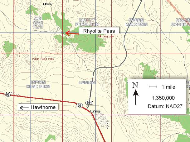
The Rhyolite Pass group of mines and prospects is located in the Gabbs Valley Range, approximately 22 airline miles northeast of Hawthorne. Although the extent of these inactive workings suggests that the area was of no great economic significance, recent investigations indicate that it is indeed, a mineralogically noteworthy locality. Based on a sketchy report of the existence of the species barium pharmacosiderite and dussertite at this locality, the site was given a cursory examination by members of the NCMA during the 2001 NCMA prospecting trip to Mineral County. On-site examination of material gathered during the field trip revealed little that was either mineralogically intriguing, or at the very least, pleasing to the eye. Fortunately, samples were collected for later investigation. Subsequent examination of this material revealed a considerable array of arsenates including most notably, the mineral arthurite. Although the minerals from this locality are small and sparsely disseminated, the number of species in occurrence is considerable and many of these minerals form well-crystallized specimens. This preliminary report will provide some general information about the locality, as well as, information dealing with the ongoing mineralogical investigation presently being performed by NCMA members. |
|
Available records on this area indicate that the claims were first located in 1944. The original claimant and the name given to the property however, could not be ascertained from the modern records. However, the matter was discussed with Bob Doyle, a resident of Mina, who related that he was one of the original operators of this property (R.W. Thomssen, personal communication, 2001). If in fact, Bob was referring to the same deposit in the Rhyolite Pass area and it is fairly certain that he was, then the original name of the property was the Ramsey mine. Bob also said that he and his partners shipped a few loads of high-grade material for their precious metal values and high silica content. This description is consistent with the type of material found in the deposits at Rhyolite Pass. The tonnage was not specified, but it is doubtful that it was a significant amount. Sometime later, the area was placed under claim by Siskon Corp. and the several contiguous claims that were filed were called the Nevada Crown claims. Later, the property was transferred to Coca Mines Inc. of Coeur d'Alene, Idaho, a predecessor of Hecla. During this period, from the 80's to the early 90's, the property was prospected via trenching and limited drilling. No mining activities were performed during this period and it would appear from the records that no work has been performed in the area at all since the early 90's. The claims on this area however, are current. Individuals desiring to collect minerals from this locality should be cognizant of the land status and take appropriate measures. |
|
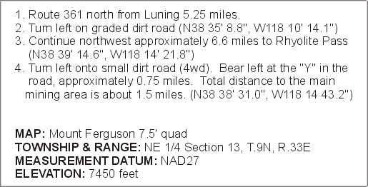
The Rhyolite Pass area is reached by taking Route 361 north from the town of Luning. Specific directions to the locality are as follows:
Upon arrival at the main mining area, a number of shallow pit workings and associated dumps will be noted. These older, original workings were the areas that yielded mineral specimens. There are also several modern trench workings surrounding the area, but they showed no evidence that any mineralized veins were intersected. The only noteworthy specimens collected from any of these prospecting trenches were a few well-crystallized samples of alunite. Although some evidence of in-situ mineralization is still present in the walls of the pit workings, most mineral samples were recovered from dump material. The dump material showed better signs of surface mineralization and it was also a great deal easier to collect, due to the thorough silicification of the host rock. On the initial NCMA field trip to this locality, only the main mining area and a few of the surrounding modern trench cuts were investigated. On a return trip to the area a few months later, a second, smaller prospect was discovered approximately 200 yards to the southeast, hidden in a grove of pine trees. This second, old-time working although small in size, is notable because it showed no sign of recent disturbance. Many excellent samples were won from material on the dump of this small prospect. |
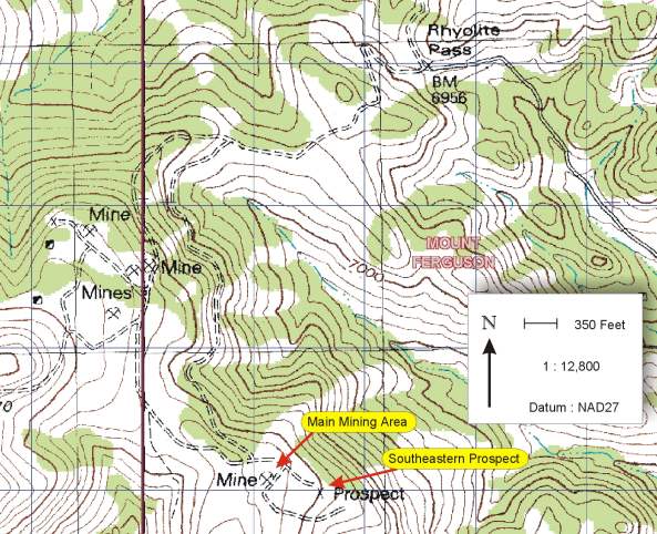
Figure 2. Detailed location map of the Rhyolite Pass area showing the main mining area and the southeastern prospect. |
|
The geology of this region is described as felsic volcanic rocks of Tertiary
age, mostly composed of rhyolite and quartz latite welded tuff (D.C.
Ross, 1961). This is an accurate portrayal of the host
rock units in the area of Rhyolite Pass. In addition,
it can be noted that the ignimbrite unit exposed in this area is particularly crystal
rich and fine grained, which suggests that it may have been the
result of a pyroclastic
surge deposit (P. Francis, 1995). The lack of any significant
welding texture indicates that the rock unit is only mildly to moderately
welded. Some degree of the induration of the host rock
can also be attributed to silicification during hydrothermal
intrusion.
Hydrothermal deposition of minerals has taken place in narrow, steeply dipping fractures in the host rock. Penetration of the mineralizing fluids along the vein walls is minimal, averaging only a few centimeters at best and there is very little evidence of host rock alteration. The secondary minerals of note have formed in small cavities, averaging a few millimeters in size, along the vein walls. The cavities have formed from the dissolution of feldspars and small lithic fragments during hydrothermal emplacement. The preponderance of pseudomorphous growths in the vein mineralogy indicates a deposition history that was prolonged, which is consistent with an epithermal origin. The similarity in mineralogy between the main mining area and southeastern prospect indicates that they were probably syngenetic and there is also a good probability that the vein structures are linked. However, no surface expression was observed indicating that there is a contiguous structure between the main mining area and the southeastern prospect. Surface trenching performed by the claimants between these two areas likewise, apparently revealed no mineralized structures. The lack of significant alteration however, would make it difficult to verify this hypothesis without detailed mapping and perhaps drilling. |
Copyright 2011 by the Northern California Mineralogical
Association
All rights reserved.